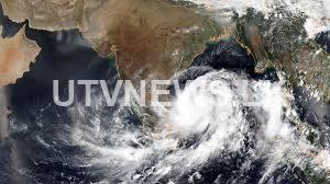
(UTV | COLOMBO) – The low pressure area over South East Bay of Bengal and neighborhood is likely to developed into a depression over same region during next 12 hours and further intensify into a cyclonic storm over South Bay of Bengal tomorrow (16), the Department of Meteorology said.
The Department said that it is very likely to move northwestwards initially till 17th and then re-curve north-northeastwards towards North Bay of Bengal during May 18 and 20.
Under the influence of the system possibility for heavy showers or thundershowers and sudden roughness, associated with sudden increase of wind speed up to 60-70kmph is high in shallow and deep see areas around the island.
The Met Department said that heavy rains about 150 mm can be expected at some places in Western, Sabaragamuwa, Southern and Central provinces.
“There is a possibility that near shore sea areas off the coast extending from Mannar to Pottuvil via Colombo, Galle and Hambanthota may experience surges due to the effect of swell waves, having 2.0-2.5 m height,” they said.
Naval and fishing communities have been advised not to venture into the shallow and deep sea areas around the Island until further notice.
Those who are out at sea over these regions are advised to return to coasts or moved safer areas immediately.
Meanwhile, people living in hilly areas, particularly landslide prone areas) have also been requested to be vigilant.

